| From NRCan wiki |
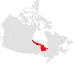
The Hudson Bay Lowland is the southern expression of a sedimentary basin centered on Hudson Bay. The terrestrial extent is ~246,000 km2 and it is bounded by Precambrian Shield rocks to the south and west. It is most extensive in Ontario with a minor extent in Manitoba, and James Bay region of Quebec (Fig. Map-1). Permafrost bounds the northern extension of the region. The area is extremely sparsely populated with hydrogeological information mainly available from studies of hydroelectric and mine sites.
The region's climate is continental and is strongly influenced by cold, moisture-laden Hudson Bay and Polar air masses. It is characterized by short cool summers and cold winters. Mean annual temperature ranges from -4 to -2°C but is closer to -7 in Manitoba. Annual precipitation averages from 400 to 800 mm, increasing from northwest to southeast. The region supports the largest organic terrain in the world as up to 75% of the area is underlain by wetlands. Poorly drained areas support dense sedge-moss-lichen covers, and less frequent and better-drained sites support open woodlands of black spruce and tamarack. Raised beaches are vegetated by black spruce and depressions are filled with bogs and fens.
Hudson Bay Lowland rises gently from sea level to ~120 m asl, and is an area of low relief with poor drainage. Precambrian Sutton Hills rise 150 m above the surrounding landscape (Fig. V-4). A series of beach ridges occur in land from the present shoreline and form a prominent element of the region. Isolated bedrock knolls penetrate the surficial cover. The low relief is a reflection of the subhorizontal sedimentary strata of the Hudson and Moose River intra-cratonic basins that are up to 1500 m and 900 m thick respectively. Both basins are dominated by carbonate bedrock with anhydrite, gypsum and lesser halite interbeds. Units locally contain bituminous limestone beds. In the Moose River Basin Cretaceous beds consist of poorly-consolidated clastic sediment and locally kaolinite mudrock and lignite. The sedimentary succession is cut by a number of Mesozoic intrusions, some of which are kimberlitic. Till occurs as a semi-continuous cover and is considerably thicker than in the shield region. Broad preglacial valleys have been infilled with more than 60 m of surficial sediment, and a thickness of 145 m has been recorded. Surface sediment is commonly glacimarine clay and sand.
There is little hydrogeological data for this region as there are few water wells and little development has occurred. Basal carbonate-evaporites form key hydrostratigraphic units in Hudson Basin and southern Manitoba and have likely equivalents in the Moose River Basin. Glacial lacustrine and glacial marine clay and till units form regional aquitards; Kaolinite-rich mudstones and lignite form local aquitard in the Moose Basin. Groundwater flows principally along joints, faults, fractures, bedding planes, and solution features in carbonate-evaporite units. Where solution features are well developed, high bulk-rock hydraulic conductivities may be present and carbonates will form a productive aquifer. Massive, finely-crystalline carbonate may have low-bulk hydraulic conductivity and the unit may locally be an aquitard. Groundwater interacts with surface water in several common watershed settings: i) shallow groundwater discharges at peat-sediment interfaces; and ii) where peat is underlain by sand and gravel. At intermediate depths, it discharges along bedrock-sediment interfaces, and deeper groundwater flows from bedrock aquifers to large rivers (Fig. V-4). Holocene karst also affects groundwater flow through vadose zone flow in limestone and sinkhole flow on or next to limestone bioherms beneath peat cover. Groundwater chemistry can have elevated sodium and chloride concentrations that is attributed to marine waters in surficial and bedrock units, as well as dissolution of evaporite units. High chloride levels (10,000 mgl-1) are reported at depths below 200 m.